The BCN Headquarters, The Titford Pumphouse.
The History of the Area.
For many years the Titford Canal has been under threat of closure and water supply problems have blighted all attempts to fully realise the potential of the canal. It is the seconded highest navigable canal in England at 511ft above sea level.
For many years, to highlight how difficult it was to navigate the canal, a plaque was available from the 'Navigation' pub by Titford Pools to any boat that made the trip. This plaque was produced by our friends at the 'Coombeswood Canal Trust' and it is hoped that both the plaque and a certificate will be available again soon to reward boat visits.
Various attempts at bringing boats back to the canal by setting up mooring schemes both on the canal or the Pools have always failed due to the water supply problem causing boats to become grounded very easily. No facility to back pump water was available and the canal had to rely on its own small supply from the Rowley Hills into the Titford Pools. Drainage from the elevated section of the Motorway brought some water but lots of silt built up over the years and has reduced the Pools from an area able to stage a National Rally with hundreds of boats attending, to the present day where it is very difficult to navigate the smaller of the two Pools without going very seriously aground.
The Pump House at the Top of the Oldbury locks fell into disrepair and the premises were let to a car repair business that appeared to the casual onlooker not to be in business. Finally the building became totally insecure and a plan was needed to save it.
A Home of Our Own.
The BCNS had long been looking for a home of its own and had been renting rooms at the Galton Valley Centre in Smethwick. When Galton Valley closed, the society maintained links with the area by holding its annual Bonfire Rally on the premices, but was forced to split its other activities between various venues.
The first venue considered as a permanent home was Chillington Wharf in Wolverhampton. The wharf was the last remaining covered interchange basin on the BCN and the society wanted to convert it into meeting rooms and moorings which would provide income for the venue's upkeep. The project unfortunately fell through but proved that interest and funding could be found for a similar project elsewhere.
|
In 2000 B.W approached the BCNS via Mike Butler and Martin O'Keffe with the first tentative ideas to restore the pumphouse. The society would become the end user of the building and this would enable British Waterways to unlock money for the restoration . This idea then kick started a moorings project on the Tatbank Branch along side the Pump house that would provide income and would also neccesitate installing new pumps in the pumphouse which would solve the longstanding water-level problems on the canal.
|
 |
The Pumphouse.
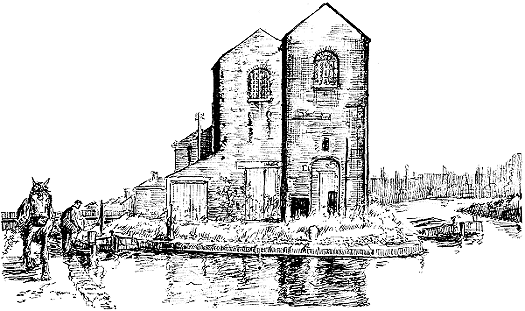
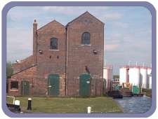
The building known as the pump house is in fact a series of buildings that have been added to and adapted as canal technology changed. Initially it was a single tall engine room with a second tall engine room being added when more pumping power was needed. This resulted in the twin building seen today. The lean too building at the side of the one engine room was built later to house a blacksmith shop. The boiler house at the rear was probably built and then enlarged when the second engine room was built.
Shortly after the restoration project began, the sight became the victim of an arson attack and the boiler room was destroyed. The cost of rebuilding this section was too high and so the restoration project was re-designed.
Today the boiler house has had its roof removed and the walls lowered to form a secure compound for both British Waterways and the society's use. The engine houses have been adapted to house a flat on the top levels providing income for up keep.
|
The second floor, houses a store room and commitee room for the society, whilst the ground floor on the Tat bank Branch side has visitor moorings with a full amenities section for boaters. Water point, elsan disposal, toilet and shower room can be found housed behind a large green door opened by a B.W key. A room in this area is used by B.W as a mess room, whilst the outside fire escape stairs give access to all upper levels. Walk around the end of the building and you come to a series of three large green doors. The first door gives access to the pump room. When fitted, the modern electric pumps will sit on top of one of the two vertical shafts that are linked by a culvert to the old main line level at the bottom of the six Oldbury locks.
|
|
The large doors next to the pump room were once the doors that gave access to the second engine house. These doors today are false the archway being bricked up, the doors being for ascetic effect only.
The door is bricked up on the inside so as to make the maximum size of room for use as a meeting room for the society. Entrance to the meeting room is effected by the last small door next to the window on the end elevation of the building.
The second shaft that was sunk into the floor of the central house so that the engine could be linked to the lower level has been capped and is below the meeting room floor.
Outside the building at the meeting room end is an area of land that at present is fenced off by a crude coldiz styled builders temporary security fence. In time this area will be fenced off from the lock area by a permanent fence in keeping with the rest of the project. The area will then form a secure and safe area for visitors moorings access by B.W key. At the other end of the building there is access from Engine Street via a pair of gates into a car park. These gates are left locked and pedestrians can only gain access using a British Waterways key. Off the car park will be the entrance to the moorings in the Tat bank Branch. The moorings will eventually be on pontoons to safe guard a colony of water voles found in the limits of the Branch. The number of boats will be reduced to avoid disturbing the colony.
| So that is where we are today in 2002. The Pump house has been restored, is now an excellent base for the BCNS and is re generating use of the canal. With the society now centring its activities more firmly on the Titford Canal it is hoped that it will prosper. However the BCNS cannot forget its obligations to the rest of the BCN , our work boat Phoenix will continue to visit as much of the system as possible. |
 |
Titford Canal.
(Highest navigable part of the BCN, being at its summit 511 ft above sea level.)
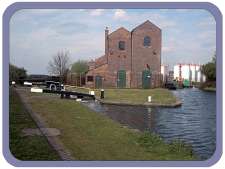
The Titford canal starts at Oldbury Locks Junction that is situated underneath the M5 motorway on the Birmingham Old Main Line in Oldbury. This area between the junction and the first lock was once a busy scene being the home of Thomas Claytons of Oldbury one of the last carriers to operate on the BCN . Their boats carried mainly liquid cargoes of crude tar and gas water to the Springfield Tar Distillery, the wharf can be seen to the left below the first lock.
The canal rises up the six Oldbury Locks passed the Crow Arm by the third lock (Locally the area is known as the Crow) to the unnamed junction by the top lock where the Tatbank Branch joins the canal. The locks are attractive to look at and a joy to operate all having wooden balance beams and traditional paddle gear.
Between the two canals stands the pump house looking as one looks back towards the locks as if the engine house is on an island.
The Tatbank branch has know been dredged and it is hoped in time when full pumping is restored that the branch will be full of moored boats. The Branch is stanched off at the first road bridge but continues through the BIP Chemical works for a further distance and has not been open for navigation for years.
Delay in finishing the mooring project has been caused by one of the largest colonies of water voles being found at the end of the arm. Plans to protect the colony are being taken so both boats and voles can live together.
After the pump house the canal passes through an almost preserved BCN scene untouched by modern development. Langley Maltings a restored brewery that dates from the 1890's makes a very photogenic back drop and a little further on Langley Forge an industrial building still in use . At the next bridge a friendly pub and a small group of houses huddle around the canal and give access to the small group of shops that is Langley. The shops consist of a Butchers ,General store, News agents, Post office and a motor vehicle factors.
Just before Uncle Bens bridge is a winding hole that was once a wharf and coal merchants, and as present later a transport company.
At Jarvis Bridge a busy road bridge is another pub the New Navigation the canal splitting into the Causeway Green and Portway Branches that in turn are connected to Titford Pools.
The Pools were once in the 70's the site of an IWA National Rally, hundreds of boats filled the pools but since silt has almost made the smaller pool at the end the Portway Branch almost innavigable.
The Black country boating festival has been held here on occasions there being good road access and ample space for a festival site. Lack of water has always been a problem but may be in future, events will once again return to the pools.
The larger of the two pools connects both branches together and can be navigate with care by all but the largest of craft. The area is dominated by the M5 motorway that crosses the pools on stilts but is full of wild birds, the islands formed by the waterways now being a wild life conservation area.
Although we have lost some of the original canal buildings it is the hope and aim of the BCNS with the support of BW to retain the whole length of the canal and its surrounding infrastructure as a microcosm of what the BCN was like, untouched by modern development.
Come and visit the area espeacially by boat, the pump house makes a safe and welcoming mooring with all the facilities bar a pump out. Exit and entry from the area to visit local hostels is by BW key.
T is for Titford...... an article by Ray Shill from Boundary Post.
Most motorists who travel along the elevated section of the M5, in the Midlands, are unaware of the canal network hidden below the motorway. A forest of supports form a concrete cocoon around a long section of the Birmingham Canal (Old Main Line) and a small canal reservoir known as Titford Pools. The remnants of the reservoir at Titford are amongst the oldest surviving features of the Birmingham Canal. The pools date from the period between 1773 and 1774 when a dam was raised to enclose a 9-acre site.
The following advertisement was published in Aris's Birmingham Gazette on July 21st, 1783:-
BIRMINGHAM CANAL NAVIGATION
GREAT Numbers of persons having of late made a Practice of ANGLING, and otherwise Fishing in the Reservoirs at Smethwick and Titford. belonging to the Company: Notice is hereby given, That all Persons who shall be found trespassing in future, will be prosecuted with the utmost Rigour; and likwise all Persons, who after this Notice, shall be seen Bathing, or sending Dogs in the Canal.
JOHN MEREDITH, Clerk to the Proprietors.
Over two hundred years have passed since the publication of this notice, but Titford still retains a role as a reservoir that supplies the Birmngham Canal Navigations and other associated waterways.
Titford Reservoir ranked with the Great Smethwick Reservoirs as an early supplier of water to the Navigation, but although the need for Smethwick Reservoir was swept away by Telford's water supply improvements made during the period , Titford Reservoir was retained and linked by a new feeder to Edgbaston Reservoir.
Titford Reservoir collects water from the hills above Rowley Regis. These same hills also provide water for the embryonic River Tame that flows through the heart of the Black Country and once provided power for a number of water mills placed strategically along its length. Telford's feeder was a narrow channel that replaced the original feeder link to the Old Birmingham Canal. Its engineering was just as complex as any navigable canal: embankments, cuts, tunnels and bridges were required. It even crossed Stoney Lane near the Blue Gates, Smethwick by a cast-iron aqueduct.
The Titford end of this feeder had but a brief existence as a narrow channel before plans were being made to widen it for navigation and link it to the Old BCN by a flight of six locks. The reasons behind this work were to enable boats to reach the coal mines being developed in the Oldbury valley. Some mines were already accessible by tramroad links down to wharves beside the Old Main Line, but a canal link promised better access to the new mines then being sunk. Alternate routes were discussed but the final solution was the line from Oldbury through to Titford Pools that involved the flight of six locks.
BCN Committee Minutes for February 1835, record a letter from Thomas Bartlett, who was agent to a Mr Willets. Willets had sunk shafts to coal measures but these mines lacked suitable canal facilities. The BCN who were already planning a branch in the area were able to reply that they were about to apply to Parliament in order to make a branch according to a plan arranged by W. Fowler. The route was to leave their existing canal near Stoney Lane Bridge and then climb through locks to join the feeder. The feeder would then be made navigable to Titford Pools. There would be two branches, one to the Portway Road beyond the Pools, whilst the other was to run to the West side of the valley.
The plans for building the canal were finalised by November 1835, when it was decided that it should be made to a top width of 30ft, a depth of 5ft and the slopes to be inclined at 1.1/2 to 1.
Work on construction went ahead thorough 1836 and 1837 on the canal, locks and feeder improvements. Work on the Portway Branch meant that the canal line had to cross in front of, or over, the old reservoir dam in some fashion, The Titford Canal was opened to traffic from October 4th 1837 and opened up a new canal communication to the brick works and coal mines around Portway and Newberry Lane, The so called western branch was evidently not built at this date. This section of waterway was finally completed as the Causeway Green Branch, which was finished during 1858. The Causewat Green Canal enabled mines such as Cakemore and Rowley Station to send coal by canal.
Once completed in 1837 this line reached the highest navigable level on the BCN, at 511ft(o.d.). Some three years later, when the BCN merged with the Wyrley & Essington Canal Company, a higher navigation, on the Essington Branch Canal came under BCN control, but this waterway had ceased to be used following mine closures and in effect, Titford has remained the highest BCN navigation to this day. Another potential candidate for the highest BCN navigation could have gone to the Dudley Canal Company, who proposed a flight of locks up from the Bumble Hole to Buffery Collieries near Dudley. Carey's Map (1796) suggests there might have been as many as 10 locks, which on an average rise of 6 feet from the Dudley No 2 canal at 453ft might have reached a similar height to Titford. The Buffery Branch was abandoned, on Thomas Dadford's recommendations, in favour of a tramway but still conjures up pictures of what might have been. Titford may be the highest navigable waterway in the Midlands, but it no longer has the honour of being the highest in England. That honour must now pass to the Rochdale Canal, which rises to a navigable summit of 600ft.
With the building of the Titford Locks and the widening of the feeder for boat navigation the need for water conservation was immediately considered. Whilst construction of the locks was underway tenders were sent out for a pumping engine to re-circulate water between the 473ft level, at Oldbury, and the 511ft Titford level. Boulton & Watt won the contract to supply a single-acting beam engine, which was erected in a house built between the top lock and the 4 1/2-mile long feeder link to Edgbaston Reservoir. A single boiler was erected in an adjoining structure, later a second boiler was provided. A close study of the Oldbury Tithe map appears to show that both buildings were aligned one behind the other.
The carriage of coal may have provided the incentive for the construction of the waterway, but other cargoes such as chemicals, phosphates, oil and tar were later to become important commodities carried along the Titford Canal. The development of Albright & Wilson's Phosphorus works would bring significant toll revenue to the canal, as would the later establishment of British Cyanides.
For some reason, yet to be discovered, Titford Locks became known as the "Jim Crow". There was also an arm or basin called the Jim Crow that joined the canal at the pound between the third and fourth lock. This branch is absent from the tithe map (1857) and may have been built to accommodate the Phosphorous Works extensions made during the 1860's. The branch name would then be derived from the name by which the lock flight was already known. This is becomes apparent when the text of a letter published as early as February 1856, in the Birmingham Journal is considered.
The author signed it with the word "Observer"
Sir, - I think that purchasers of coal from collieries along the Titford Canal ought to be made aware of the extent to which depredations are carried out all along the " Jim Crow" Locks. I am a daily observer of these depredations and cannot pass over such things in silence. I see enormous lumps of the best coal thrown out by the boatman in considerable quantities onto the side of the locks, as the boats are passing through, and thence carried to the adjoining houses by women, boys and girls.......
As traffic on the Titford Canal increased demand for additional pumping power became an urgent requirement. It was decided to purchase an additional pumping engine, which also involved the sinking of a parallel pumping shaft. The engine house was also reconstructed at the same time, whereby the original and second engines were located side by side in adjacent engine halls. The second engine was erected between 1863 and 1864. It was a beam engine made by G & J Davis of Tipton that was purchased second-hand from the South Staffordshire Waterworks Company.
At some later date a blacksmith shop, in a lean-to building, was made alongside the engine house facing the lock side.
Both engines were retained at Titford until the traffic decline of the 1920's. The Boulton and Watt engine was cut up in 1928, whilst the Davis engine was scrapped in 1937. A Tangye Oil engine replaced them, from 1928, which remained here until 1965.
Edward Paget Tomlison's drawing (at the being of this section) reflects a time before the steam boilers had been taken out of use. A boat is shown in the top lock chamber, whilst another lies tied up on the feeder arm loaded with coal for the boilers. A short section of the feeder beyond the engine house had been made navigable to supply the Titford engines. Later the navigation was extended as far as Adams coal yard and the BIP (former British Cyanides) Chemical Works. In some accounts the name for this navigable section is given as the Tatbank, or Spon Lane, Branch. BCN distance tables simply refer to it as a feeder. There were other canal side buildings not shown in this view including a canal house and stable block that lined the towpath near the top lock.
Some of the last traffic on the branch included coal to Langley Forge from Cannock Chase. All local mines had long since closed and loaded coal boats passed up the "Crow", rather than down it. When this traffic ceased in the 1960's the Titford Canal quickly became over grown and weeded. Were it not for the 1970's clean up campaign and subsequent boat rallies, the future of the waterway might have been the same as the Ridgeacre and it might have been closed to navigation for good.
Fortunately members of the BCN Society, IWA and other local groups each played a part in preserving a portion of the BCN heritage. It has not been possible to stop the loss of certain structures such as the stables and canal house, which have both been demolished, but the engine houses are veteran survivors. Despite a serious arson attack the buildings were refurbished by British Waterways, in 2001, to provide residential accommodation, a meeting room, boaters facilities and a new pump room.
Whilst reconstruction was underway, it was possible to see how the buildings were put together. The engine house nearer the Tatbank Branch was evidently older than that nearer the lock side and there was a large bricked up archway that may have formed a communication between the two halls. It was decided not to restore the boiler house at the rear, and the structure was partially taken down. When the boiler house wharf below the top lock was cleansed of rubbish a short brick arched tunnel was discovered, which may have been used to convey the ashes from the boiler to a boat moored beside the wharf.
Even at this late stage, Titford Pump house had secrets to give up. It is also a remarkable achievement that a nineteenth century structure has found a new role as part of a twenty-first century waterway. So many more buildings are lost to the planner's whim. Titford Pools are a prime example of planners dreams. When "Conurbation", a book which showed the West Midlands as it was at the end of the Second World War and which gave an optimistic view of how it could be improved, was published in the 1940's an artist touched up a picture of the pools to show then filled with sailing yachts and people swimming. Such were the immediate post-war hopes. The planners of the M5 motorway were to end this dream. The elevated motorway neatly bisects the Pools, its concrete supports sunk deep into the bed of the reservoir !
More articles on the Titford Canal can be found here.
|